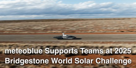
meteoblue Ad-free 9 €
Icon
Partly cloudy
Partly cloudy
Partly cloudy
Mixed with showers
Overcast
Overcast
Partly cloudy
Clear with few low clouds
Temperature (°F)
39°
39°
38°
38°
44°
44°
53°
53°
55°
55°
48°
48°
40°
40°
35°
35°
Temperature felt (°F)
33°
32°
39°
50°
49°
40°
33°
27°
Wind direction
NE
NE
NE
NE
ENE
ENE
NNE
NE
Wind speed (mph)
NE
1-9
1-9
NE
3-10
3-10
NE
1-13
1-13
NE
5-19
5-19
ENE
7-21
7-21
ENE
7-24
7-24
NNE
5-22
5-22
NE
4-17
4-17
Precipitation (in/3h)
-
5%
-
-
0%
-
-
0%
-
< 0.04 in
25%
< 0.04
-
20%
-
-
20%
-
-
10%
-
-
10%
-
Precipitation probability
5%
0%
0%
25%
20%
20%
10%
10%
Precipitation hourly

00:00 to 01:00:
5% chance of precipitation in the area.
0″ are predicted by our local models.

01:00 to 02:00:
5% chance of precipitation in the area.
0″ are predicted by our local models.

02:00 to 03:00:
0% chance of precipitation in the area.
0″ are predicted by our local models.

03:00 to 04:00:
0% chance of precipitation in the area.
0″ are predicted by our local models.

04:00 to 05:00:
0% chance of precipitation in the area.
0″ are predicted by our local models.

05:00 to 06:00:
0% chance of precipitation in the area.
0″ are predicted by our local models.

06:00 to 07:00:
0% chance of precipitation in the area.
0″ are predicted by our local models.

07:00 to 08:00:
0% chance of precipitation in the area.
0″ are predicted by our local models.

08:00 to 09:00:
0% chance of precipitation in the area.
0″ are predicted by our local models.

09:00 to 10:00:
10% chance of precipitation in the area.
0″ are predicted by our local models.

10:00 to 11:00:
10% chance of precipitation in the area.
0″ are predicted by our local models.

11:00 to 12:00:
25% chance of precipitation in the area.
0″ are predicted by our local models.

12:00 to 13:00:
10% chance of precipitation in the area.
0″ are predicted by our local models.

13:00 to 14:00:
15% chance of precipitation in the area.
0″ are predicted by our local models.

14:00 to 15:00:
20% chance of precipitation in the area.
0″ are predicted by our local models.

15:00 to 16:00:
20% chance of precipitation in the area.
0″ are predicted by our local models.

16:00 to 17:00:
10% chance of precipitation in the area.
0″ are predicted by our local models.

17:00 to 18:00:
10% chance of precipitation in the area.
0″ are predicted by our local models.

18:00 to 19:00:
10% chance of precipitation in the area.
0″ are predicted by our local models.

19:00 to 20:00:
10% chance of precipitation in the area.
0″ are predicted by our local models.

20:00 to 21:00:
10% chance of precipitation in the area.
0″ are predicted by our local models.

21:00 to 22:00:
10% chance of precipitation in the area.
0″ are predicted by our local models.

22:00 to 23:00:
5% chance of precipitation in the area.
0″ are predicted by our local models.

23:00 to 00:00:
5% chance of precipitation in the area.
0″ are predicted by our local models.

rainSPOT Precipitation distribution within 20 km
1h view
Hourly view
The weather forecast has high predictability. Compare different forecasts with MultiModel.

Weather report for St. Leonhard in Passeier

Overnight into Thursday a few clouds are expected and on Thursday morning some wet spells with showers are mixed in. For the afternoon the sky remains overcast. The sun will not be visible. Temperatures peaking at 55 °F. Night and day blows a light breeze (4 to 8 mph). Gusts to 26 mph are possible. Winds blowing from Northeast. The weather forecast for St. Leonhard in Passeier for Thursday is likely to be accurate.

sun-icon
UV 3
06:19
20:09
Waxing gibbous moon (120°)
14:29
04:37

Pressure: 1012 hPa

Timezone: CEST (UTC +02:00h)

Radar and precipitation nowcast for St. Leonhard in Passeier

Drizzle
Light
Moderate
Heavy
Very Heavy
Hail

The location marker is placed on St. Leonhard in Passeier. This animation shows the precipitation radar for the selected time range, as well as a 2h forecast. Orange crosses indicate lightning. Data provided by nowcast.de (available in USA, Europe, Australia). Drizzle or light snow fall might be invisible for the radar. Precipitation intensity is colour coded, ranging from turquoise to red.

Meteogram - 5 days - St. Leonhard in Passeier

meteoblue
Our 5-day meteogram for St. Leonhard in Passeier offers all weather information in 3 simple graphs: [More]
  • Temperature chart with weather pictograms. The yellow background indicates daylight.
  • Clouds in different altitudes: from few clouds (light grey) to overcast (dark grey). Dark blue bars show hourly precipitation and light blue showers. An asterisk indicates snow fall.
  • Forecasts for wind speeds are blue and for gusts are green. The arrowheads point in the same direction as the wind.

You can embed this meteogram into your own website with the following HTML code. In doing so, you agree to our non-commercial use conditions.

Current satellite and rain images for St. Leonhard in Passeier, Italy

The location marker is placed on St. Leonhard in Passeier. [More]

The real-time satellite image combines visible light during daytime with infrared radiation during nighttime. At night, the image is not dark as infrared radiation can detect temperature differences. Unfortunately, low clouds and fog are difficult to distinguish from ground temperatures and thus can be almost invisible during the night. Meteosat satellite images for Europe are updated in real-time every 5 minutes. GOES-16/GOES-17 (North & South America) and Himawari (Asia) images update every 10 minutes.

Precipitation is estimated from radar and satellites. Precipitation estimates from satellites are less accurate at night than during daytime.

© 2024 meteoblue, NOAA Satellites GOES-16 and EUMETSAT. Lightning data provided by nowcast.

Back to top
×
Hey there,
seems like you are using an ad blocker.

Advertising is essential to maintain our free website with unique detail and accuracy.

Please whitelist www.meteoblue.com on your ad blocker or consider buying one of our products:

Already have a subscription?
Then please login.